Tuesday 27 August
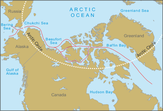
From Nome to Tuk we had experienced positive north and then east running currents. In fact in the Bering Strait these had been at times in excess of 1 Kt.. Now we are experiencing the slights effects of tidal movement. Little more than 0.5 Kt., either helping us along or opposing us; depending on the tides state. During the early morning we navigated around various islands, sprinkled out across the sea. We passed between Douglas Island to the west and Lady Franklin Point to the east. Here a traffic separation lane exists as the channels narrow in place and clearly a tug, towing barges in a line that could be 500 metres or more in length as we have seen will need their space and have limited manoeuvrability. As we turned more easterly into Coronation Gulf we had c. 190nm to run to Cambridge Bay.
With so much solitude despite sharing the 33' of space with four others its amazing where the mind wanders. I ended up writing a list of things I need to do (believe me there is always more to do than you would think on a boat). High on the list, and the benefit of bringing my lap top with me is to get my curriculum vitae up to date as this adventure will come to an end - sooner or later depending on the ice situation east of Cambridge and I will need a job! Likewise, I have not heard any news, national or international for four weeks - for all I know the economy is sorted, Prince Harry is engaged to a quiet, dull character and the Spice Girls are No. 1 in the charts… then again most times I go away the economy takes a nose dive and the FTSE crashes. I digress….
At lunchtime we closed into the shore off Victoria Island north of the Duke of York archipelago of islands to test the underwater filming equipment. The weather had become positively summery at 13 degrees Celsius. Dinner that evening was Bob's standard fare… a tin of spam, a tin of sweet corn, a tin of mushrooms and a jar of sweet and sour sauce, ladled elegantly over boiled rice. It actually is quite nice. By rationing Bob's time at the galley means that there is no obvious notice of repetition. Though Karen and Steph's faces are a picture if they are washing up as there is always a fair amount of residue of the fine dish around the galley, behind the cooker and on the cabin sole (floor).
The last leg has been somewhat devoid of wildlife. We see the odd seal, the odd bird but little else. Slightly disappointing, though if you were a twitcher (I am definitely not) I am sure you could tell the species part, to the uneducated Richard there are seagulls, black birds and things in-between. What is awe-inspiring is the fact that much of the water we have crossed is solid ice during the winter.
Wednesday 28 August
Another day, another low un-photogenic island to pass. The day started damp, with light drizzle. I really am looking forward to a change of scenery. I never imagined that the entire trip to date would have such boring vistas… i'm sorry but there really isn't another word for it. I'm not complaining about the adventure, but for some reason my preconceived idea was more Greenland / Scotland / New Zealand and less…. well less moon like.
What is fascinating however is the place names. Whether inlet, island,river or headland the names always have a significant historical link and associated story. However the more mundane parts are in the main unnamed. This has led me to the decision that I am going to name some of the places we have been to which are at present "unnamed".
We stopped mid morning to do a further seabed filming session having last night confirmed after a lengthy data download that the video was a success. Like the landscape, the seabed has limited visual appeal with few plant growth, only a few sea urchins and star fish. Nothing so far thats going to get me an Oscar under the real life documentary category. Having said that, the crew huddle round the real time video monitor when I'm trawling the camera as it is quite addictive.
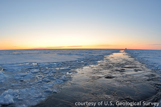
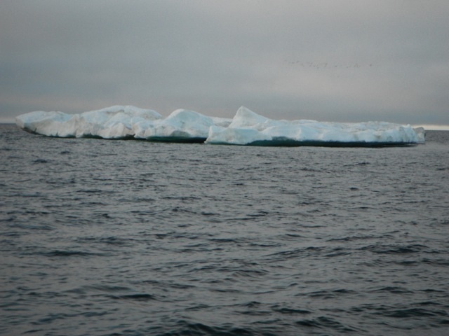
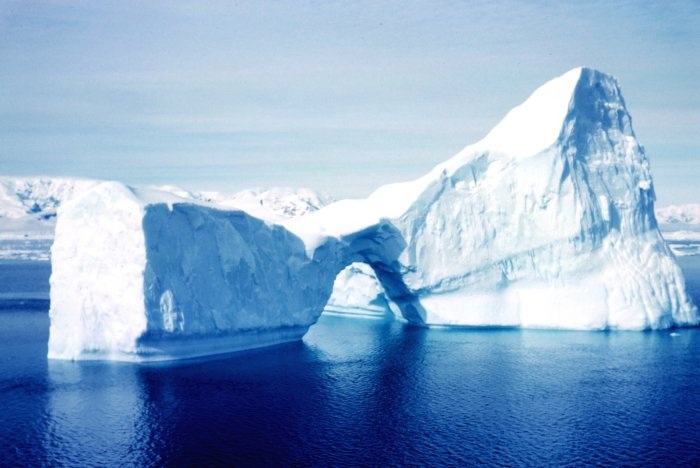
The ice situation has worsened over the past 24-48 hours. However, up here the situation changes very quickly. There are now 5/10th's ice where we encountered 2/10th's back at Cape Bathurst. More concerning, bearing in mind our easterly objectives is that whilst Bellot Strait is currently open, there is also 5/10th's ice in Prince Regent Inlet. If we were to go for it, the danger is once through the Bellot Strait the ice may close up thereby cutting our escape route back. If Prince Regent is open enough to enable us to get to Fort Ross on Somerset Island that is beneficial, but if we are then stuck as autumn closes in there is no where to lift the boat out.
As we approached Cambridge Bay a yacht motor sailed towards us. On calling them up on the VHF they had been one of the western bound crowd this year (c.5-6 boats) and the first to leave Cambridge Bay after a short 36 hr stopover. The weather by mid afternoon was glorious. The sun shone, blue sky and a light breeze from the south. Just outside the harbour a small dingy was being sailed, with tan sails and a small gaff. Slight;y incongruous to the surroundings but we thought, good on the locals to enjoy their harbour sailing… oh how wrong we were!
The entrance to Cambridge Bay consists of three sets of leading marks. Each set leading you anti-clockwise into the harbour itself. We arrived about 1500 hrs local to the most odd sight: a cruise liner anchored in the bay! In fact, this is a fairly common experience now as one or two companies run either through the NW passage if clear, or in or out of both the east and western approaches. This year their ability to make the passage has been thwarted but they now are heading to Nome. It slightly spoils our Corinthian spirit but thats the world.
We were however expecting the west bound yachts that we found tied up at the pier in Cambridge Bay. These five boats had concertinaed together due to the ice to the East. Some are planning to venture further West, a few are planning to winter here in Cambridge Bay.
The big surprise of the afternoon was the arrival, just after us of the small sailing dingy we had seen on our approach and overtaken. On closer inspection she was about 18' long, and quite high tech despite her tanned sails and gaff rig. She sported a carbon fibre mast, sets of carbon sculling oars and the odd Go Pro camera mounted to the stern and the mast head. Crewed by two Australians, in dry suits they had sailed from Inuvik on the Mackenzie River. Camping ashore at night, rowing when there was no wind. Mad… definitely.
They moored alongside an equally mad bunch of adventurers. A rowing boat (of the type used in trans-Atlantic rowing races) with four Irishmen. These guys were rowing the same route as the Australians, and like them had called it a day at Cambridge Bay. By coincidence I had heard of their trip before departing the UK from the Marketing Director of Dubarry, the Irish company who had provided my sea boots. These guys were typically full of craic. They mused about having a day of rowing (8 hours) where they only made 950m of progress!). Their hands were battered and they readily admitted that they were glad it was over.
With all these boats congregating together it has been an experience of a sudden cultural change… one minute only ourselves to talk to and the next a group of multinational adventurers each with their own experiences. It looks like therefore that there will be a nine boats either completing or part completing the passage this year - and with the exception of the elusive Polar Bound we have met them all now.
Following mooring up alongside an aluminium 45' Canadian yacht we got straight onto sourcing gas (we got two cylinders and the regulators fit!) and fuel bunkered (c.350 litres). We intend only to hang around for a day or so being ready to make the rush through Prince Regent Sound. We have completed approximately 1950 miles with a further 1600 to go to Greenland… ice depending.
Tomorrow is run ashore day! Oh the delights of Cambridge Bay awaits.
Richard
From Nome to Tuk we had experienced positive north and then east running currents. In fact in the Bering Strait these had been at times in excess of 1 Kt.. Now we are experiencing the slights effects of tidal movement. Little more than 0.5 Kt., either helping us along or opposing us; depending on the tides state. During the early morning we navigated around various islands, sprinkled out across the sea. We passed between Douglas Island to the west and Lady Franklin Point to the east. Here a traffic separation lane exists as the channels narrow in place and clearly a tug, towing barges in a line that could be 500 metres or more in length as we have seen will need their space and have limited manoeuvrability. As we turned more easterly into Coronation Gulf we had c. 190nm to run to Cambridge Bay.
With so much solitude despite sharing the 33' of space with four others its amazing where the mind wanders. I ended up writing a list of things I need to do (believe me there is always more to do than you would think on a boat). High on the list, and the benefit of bringing my lap top with me is to get my curriculum vitae up to date as this adventure will come to an end - sooner or later depending on the ice situation east of Cambridge and I will need a job! Likewise, I have not heard any news, national or international for four weeks - for all I know the economy is sorted, Prince Harry is engaged to a quiet, dull character and the Spice Girls are No. 1 in the charts… then again most times I go away the economy takes a nose dive and the FTSE crashes. I digress….
At lunchtime we closed into the shore off Victoria Island north of the Duke of York archipelago of islands to test the underwater filming equipment. The weather had become positively summery at 13 degrees Celsius. Dinner that evening was Bob's standard fare… a tin of spam, a tin of sweet corn, a tin of mushrooms and a jar of sweet and sour sauce, ladled elegantly over boiled rice. It actually is quite nice. By rationing Bob's time at the galley means that there is no obvious notice of repetition. Though Karen and Steph's faces are a picture if they are washing up as there is always a fair amount of residue of the fine dish around the galley, behind the cooker and on the cabin sole (floor).
The last leg has been somewhat devoid of wildlife. We see the odd seal, the odd bird but little else. Slightly disappointing, though if you were a twitcher (I am definitely not) I am sure you could tell the species part, to the uneducated Richard there are seagulls, black birds and things in-between. What is awe-inspiring is the fact that much of the water we have crossed is solid ice during the winter.
Wednesday 28 August
Another day, another low un-photogenic island to pass. The day started damp, with light drizzle. I really am looking forward to a change of scenery. I never imagined that the entire trip to date would have such boring vistas… i'm sorry but there really isn't another word for it. I'm not complaining about the adventure, but for some reason my preconceived idea was more Greenland / Scotland / New Zealand and less…. well less moon like.
What is fascinating however is the place names. Whether inlet, island,river or headland the names always have a significant historical link and associated story. However the more mundane parts are in the main unnamed. This has led me to the decision that I am going to name some of the places we have been to which are at present "unnamed".
We stopped mid morning to do a further seabed filming session having last night confirmed after a lengthy data download that the video was a success. Like the landscape, the seabed has limited visual appeal with few plant growth, only a few sea urchins and star fish. Nothing so far thats going to get me an Oscar under the real life documentary category. Having said that, the crew huddle round the real time video monitor when I'm trawling the camera as it is quite addictive.
The ice situation has worsened over the past 24-48 hours. However, up here the situation changes very quickly. There are now 5/10th's ice where we encountered 2/10th's back at Cape Bathurst. More concerning, bearing in mind our easterly objectives is that whilst Bellot Strait is currently open, there is also 5/10th's ice in Prince Regent Inlet. If we were to go for it, the danger is once through the Bellot Strait the ice may close up thereby cutting our escape route back. If Prince Regent is open enough to enable us to get to Fort Ross on Somerset Island that is beneficial, but if we are then stuck as autumn closes in there is no where to lift the boat out.
As we approached Cambridge Bay a yacht motor sailed towards us. On calling them up on the VHF they had been one of the western bound crowd this year (c.5-6 boats) and the first to leave Cambridge Bay after a short 36 hr stopover. The weather by mid afternoon was glorious. The sun shone, blue sky and a light breeze from the south. Just outside the harbour a small dingy was being sailed, with tan sails and a small gaff. Slight;y incongruous to the surroundings but we thought, good on the locals to enjoy their harbour sailing… oh how wrong we were!
The entrance to Cambridge Bay consists of three sets of leading marks. Each set leading you anti-clockwise into the harbour itself. We arrived about 1500 hrs local to the most odd sight: a cruise liner anchored in the bay! In fact, this is a fairly common experience now as one or two companies run either through the NW passage if clear, or in or out of both the east and western approaches. This year their ability to make the passage has been thwarted but they now are heading to Nome. It slightly spoils our Corinthian spirit but thats the world.
We were however expecting the west bound yachts that we found tied up at the pier in Cambridge Bay. These five boats had concertinaed together due to the ice to the East. Some are planning to venture further West, a few are planning to winter here in Cambridge Bay.
The big surprise of the afternoon was the arrival, just after us of the small sailing dingy we had seen on our approach and overtaken. On closer inspection she was about 18' long, and quite high tech despite her tanned sails and gaff rig. She sported a carbon fibre mast, sets of carbon sculling oars and the odd Go Pro camera mounted to the stern and the mast head. Crewed by two Australians, in dry suits they had sailed from Inuvik on the Mackenzie River. Camping ashore at night, rowing when there was no wind. Mad… definitely.
They moored alongside an equally mad bunch of adventurers. A rowing boat (of the type used in trans-Atlantic rowing races) with four Irishmen. These guys were rowing the same route as the Australians, and like them had called it a day at Cambridge Bay. By coincidence I had heard of their trip before departing the UK from the Marketing Director of Dubarry, the Irish company who had provided my sea boots. These guys were typically full of craic. They mused about having a day of rowing (8 hours) where they only made 950m of progress!). Their hands were battered and they readily admitted that they were glad it was over.
With all these boats congregating together it has been an experience of a sudden cultural change… one minute only ourselves to talk to and the next a group of multinational adventurers each with their own experiences. It looks like therefore that there will be a nine boats either completing or part completing the passage this year - and with the exception of the elusive Polar Bound we have met them all now.
Following mooring up alongside an aluminium 45' Canadian yacht we got straight onto sourcing gas (we got two cylinders and the regulators fit!) and fuel bunkered (c.350 litres). We intend only to hang around for a day or so being ready to make the rush through Prince Regent Sound. We have completed approximately 1950 miles with a further 1600 to go to Greenland… ice depending.
Tomorrow is run ashore day! Oh the delights of Cambridge Bay awaits.
Richard


 RSS Feed
